Unmanned aerial vehicle surveying and remote sensing
Unmanned aerial vehicle surveying and remote sensing
Concept
Drone aerial surveying is a powerful supplement to traditional aerial photogrammetry methods, with characteristics such as maneuverability, efficiency, speed, precision, accuracy, wide applicability, and short production cycle. The combination of drones and aerial photogrammetry makes "drone digital low altitude remote sensing" a new development direction in the field of aerial remote sensing. Drone aerial photography can be widely used in major national engineering construction, disaster emergency response and handling, land supervision, resource development, new rural and small town construction, especially in basic surveying and mapping, land resource survey and monitoring, land use dynamic monitoring, digital city construction, and emergency disaster relief surveying and mapping data acquisition, with broad prospects
Application scenarios:
- Land surveying and mapping can quickly obtain aerial photography data, so that staff can control the detailed situation of the survey area in real time. It has important applications in dynamic monitoring and investigation of land resources, updating of land use and cover maps, and monitoring of dynamic changes in land use. High resolution aerial images can also be used for regional planning, etc
- Draw a digital map, analyze the aerial images transmitted back using modeling methods, and then use a triangulation system to construct a three-dimensional model. Then, input the data into it and finally obtain the nuclear line image
- Agricultural and forestry analysis can provide accurate land texture and crop classification information, which can be used in fields such as agricultural land analysis, crop growth analysis, crop type identification, agricultural environment investigation, aquaculture area monitoring, and forest fire monitoring
- Emergency disaster relief, fully utilizing the characteristics of flexibility and maneuverability, timely acquisition of disaster area image data, has played a crucial role in disaster relief deployment and post disaster reconstruction
- Power line inspection, through refined and channelized regular inspections of power grid towers, improves inspection efficiency and reduces personnel work risks. Based on high-definition image data and combined with data analysis, achieve fault warning and on-site evidence collection
Zongheng JOUAV CW-30 Dapeng Vertical Takeoff and Landing Fixed Wing Unmanned Aerial Vehicle
! [drone] (/survey/drone. jpg) CW-30 is a fixed wing unmanned aerial vehicle with a dual tail support layout and a rear push hydraulic vertical takeoff and landing. This drone has the characteristics of vertical takeoff and landing, fully autonomous flight, long endurance, fast speed, large payload, stable structure, and high reliability. The CW-30 connection structure adopts a quick lock device, which can be quickly disassembled into 10 parts; The expansion and withdrawal time is less than 10 minutes.
Ground station technical specifications
- Professional grade tablet computer;
- Pre installed authorization for Windows 10 system on ground stations;
- Portable wireless data transmission radio: 2.4G radio with a communication distance of about 30 kilometers;
- Automatic route planning software
Drone performance
- Wingspan: 4m;
- Body length: 2.2m;
- Maximum takeoff weight: 34kg;
- Task load: 3-6kg;
- Flight ceiling: 6000m;
- Control radius: 20000m;
- Homework height: 100~5500m;
- Battery life: 3-6 hours;
- Maximum lifting speed: 10m/s;
- Extreme cruise speed: 100KM/h;
- Wind resistance strength: capable of withstanding wind speeds up to level 7;
Typical case
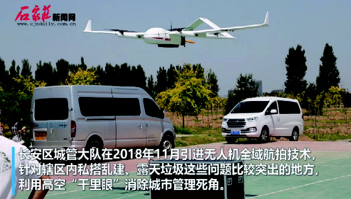
Chang'an District Urban Management Inspection
 Quickly obtain aerial images through drone aerial surveys, perform remote sensing interpretation, classify land cover types, obtain spot information on open-air garbage, illegal constructions, and waste collection stations, improve the exposure rate of blind spots that were difficult to detect manually in the past, enhance the efficiency of garbage detection, and save manpower Cost. Through the information management platform, the process is regularized. The information on outdoor garbage, illegal construction, and waste collection stations recorded in the garbage information database is given to the corresponding urban management department by type, and then the urban management department distributes tasks to each office by street. Track the entire process from "discovery division of labor cleaning verification" to achieve business process, detailed responsibility, departmental management, and street level handling. Digitize the results through an information management platform, perform big data statistics and analysis on all historical data in the business process, and form automated digital reports. Make the overall, street, and different time detection of garbage, garbage disposal, and changes in the total amount of garbage clear at a glance, achieving real-time viewing, accurate data, rapid summarization, and one click reporting. Through the intelligent one click comparison function of the information management platform, it is possible to quickly perceive the changes in the amount of garbage in the entire Chang'an District during a specified time period, and to track the change curve of a certain type of garbage information on a specified street with precision. And it is necessary to compare the results between different streets, so as to make the performance evaluation between each street more active and create a good atmosphere for work evaluation and reporting. Complete project aerial image production, system software development, and comparative report preparation. Other projects: 2019 Chang'an District Urban Construction Plan Road Construction Project Pipeline Detection, etc ###Internal construction channel project (oblique photography) for the renovation of shantytowns in Rongdong area of Xiong'an New District by CCCC Second Highway Engineering Co., Ltd
Aerial photography of internal construction channels in Rongdong area of Xiong'an New Area shantytown renovation
- Airfield area: The scope of a single mapping is approximately 4.3 square kilometers, with a total of two phases implemented and a total area of 8.6 square kilometers;
- Realistic 3D model production: approximately 8.6 square kilometers. Settlement will be based on the actual production area.
- Achievement coordinate system: CGCS2000, central meridian: 116 °, 85 elevation system.
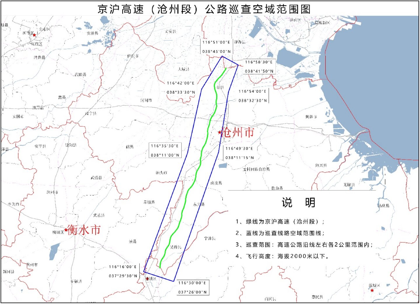
Digital Aerial Photography Project of Beijing Shanghai Expressway (Cangzhou Section)
The Beijing Shanghai Expressway (Cangzhou section) is located at longitude 116 ° 20 '-116 ° 55' E and latitude 37 ° 30 '-38 ° 42' N. It borders Tianjin City to the north, runs through Cangzhou City, and connects with Dezhou City in Shandong Province to the south. The survey area is a north-south line with a total length of approximately 142 kilometers. The territory is the North China Plain. Cangzhou is located in the east of the Central Hebei Plain. The terrain is low and flat with little fluctuation. The highest sea wave is 17 meters and the lowest is 2 meters. The terrain slopes from southwest to northeast, with the western part being a part of the alluvial fan edge in front of the Taihang Mountains, the central part being a vast plain formed by the alluvial deposits of rivers such as the Yellow River, Zhang River, Hutuo River, and Tang River, and the eastern part being a coastal and lacustrine plain formed by tidal accumulation in the Bohai Sea. 
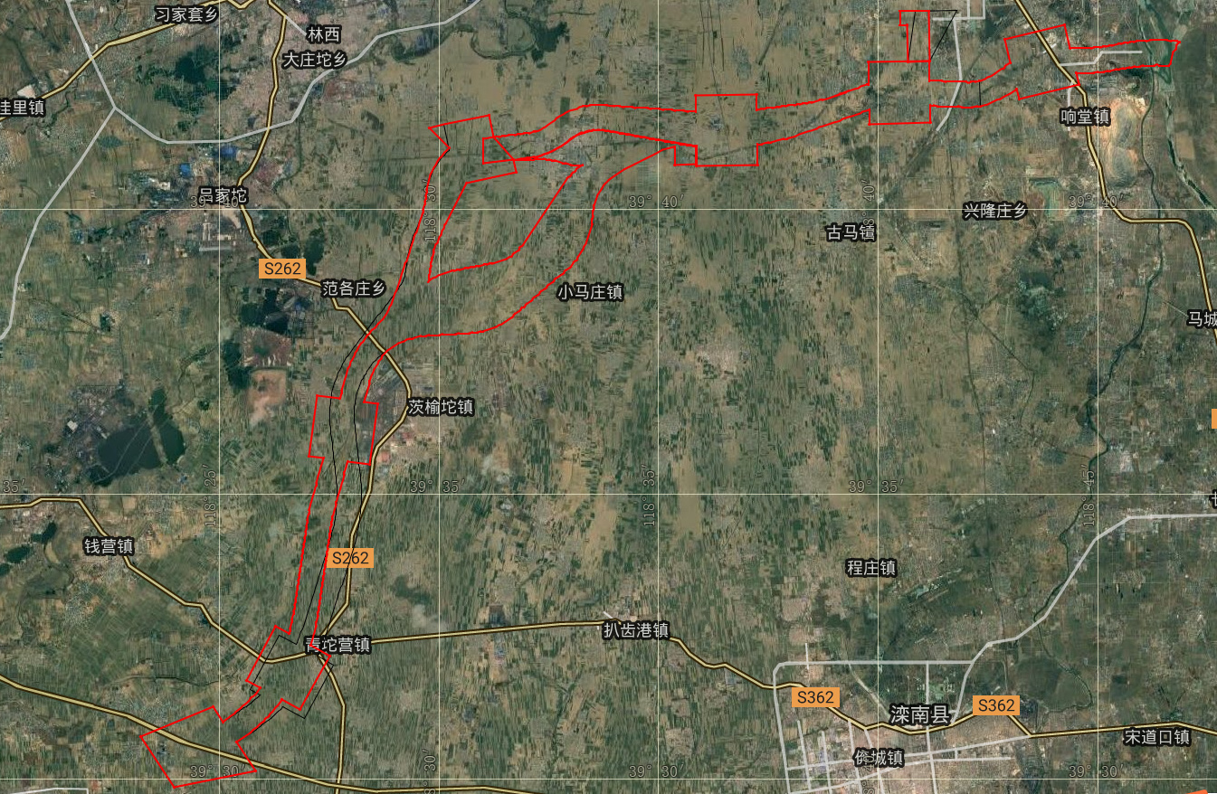
Tangqin Expressway (Tangshan section) Aerial Photography Project
The Tangqin Expressway (Tangshan section) is located at longitude 118 ° 46 '-118 ° 23' E and latitude 39 ° 42 '-39 ° 30' N. It borders Luan County to the north and Shuangtuo Town in Fengnan District to the south. The survey area is narrow from north to south, with a total length of 48.05 kilometers, a width of 1-6.5 kilometers, and a total area of 75.298 square kilometers. 